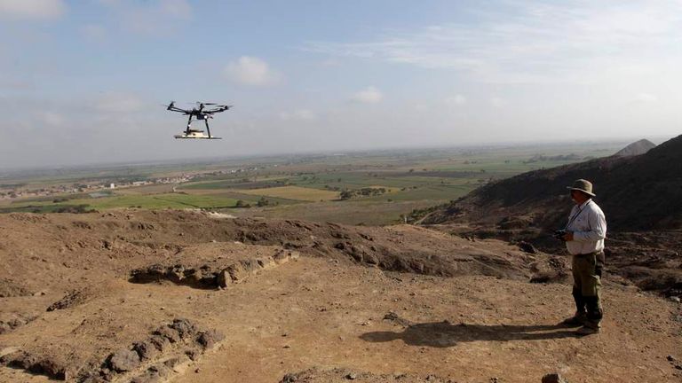
Archaeological site documentation creates a detailed record of structures, landscapes, features, and changing site conditions. Drone Archaeology Services improve this process by capturing high-resolution aerial imagery and spatial data with UAVs. Photogrammetry can transform overlapping photographs into 3D models and orthomosaics, while LiDAR can generate detailed terrain data. These digital records help archaeologists document fragile sites, analyze landscapes, monitor changes, and support cultural heritage preservation without relying only on ground-based observations.
Quick Answer: How are drones used in archaeological site documentation?
Drones capture high-resolution aerial imagery and spatial data that can be processed into orthomosaics, point clouds, terrain models, and 3D representations. These datasets help researchers document site conditions, analyze landscapes, and create repeatable digital records while reducing unnecessary physical disturbance.
Why Does Archaeological Site Documentation Matter?
Archaeological site documentation preserves spatial information that researchers may need years after fieldwork ends.
Archaeological sites can change because of erosion, vegetation growth, construction, flooding, natural disasters, tourism, and human activity. A detailed digital record can establish the condition of a site at a specific point in time.
Traditional archaeological documentation can include:
- Ground photography
- Measured drawings
- Total station surveys
- GNSS measurements
- Written field notes
- Excavation records
- Manual mapping
These methods remain important. Drone mapping adds an aerial perspective and can capture relationships between individual structures and the wider landscape.
How Does Digital Documentation Support Heritage Preservation?
Digital documentation can create:
- Georeferenced site maps
- 3D models
- Point clouds
- Orthomosaics
- Digital terrain models
- GIS layers
- Repeat-survey datasets
Researchers can compare these records with future surveys to identify changes.
For example, a heritage organization could survey an exposed archaeological structure after documentation and repeat the survey following a major storm. Comparing the datasets may reveal erosion or structural changes.
Key Takeaway: Archaeological documentation creates the baseline. Drone mapping adds scalable spatial information that can strengthen research, monitoring, and preservation workflows.
What Role Do Drones Play in Archaeological Mapping?
Drones extend archaeological observation from ground-level inspection to aerial and three-dimensional mapping.
The workflow can be viewed as:
Ground Observation → Aerial Mapping → 3D Geospatial Documentation → GIS Analysis → Archaeological Interpretation
A UAV can cover areas that would require substantial walking or ground-based surveying. This capability becomes useful when sites contain steep terrain, large landscapes, dense vegetation, ruins, or restricted-access areas.
Drone Archaeology can support:
- Large-area site mapping
- High-resolution aerial imagery
- Landscape documentation
- Repeat surveys
- Excavation monitoring
- 3D reconstruction
- Terrain analysis
- Cultural heritage records
Drones do not replace archaeologists. Archaeologists interpret features, establish research objectives, assess evidence, and place spatial observations within historical and cultural contexts.
The UAV provides data. Archaeological expertise determines what the data means.
Key Takeaway: UAV archaeology works best as a complementary technology within a broader archaeological survey and research methodology.
How Does an Archaeological Drone Mapping Workflow Work?
A successful Archaeological Drone Mapping project begins with the research question and ends with a quality-controlled dataset.
1. Define the Research Objective
The research objective determines what the drone survey should capture.
Possible objectives include:
- Documenting an archaeological site
- Mapping structures
- Recording excavation areas
- Monitoring erosion
- Supporting conservation
- Mapping archaeological landscapes
- Creating a digital archive
- Comparing site conditions over time
A project focused on structural documentation may require detailed photogrammetry. A landscape project may benefit from LiDAR-derived terrain information.
2. Assess the Archaeological Site
Site assessment identifies environmental, technical, archaeological, and operational constraints.
The survey team should consider:
- Terrain
- Vegetation
- Structures
- Accessibility
- Site boundaries
- Weather
- Airspace
- Flight restrictions
- Sensitive areas
- Required ground control
Archaeological sites often contain fragile structures or sensitive cultural resources. Flight planning should therefore consider both data quality and site protection.
3. Plan the UAV Mission
Flight planning determines how consistently the drone collects aerial information.
Important variables include:
- Flight altitude
- Survey boundary
- Image overlap
- Ground Sampling Distance (GSD)
- Flight speed
- Flight paths
- Terrain
- Lighting
- Safety requirements
Photogrammetry requires sufficient overlap between images. The software uses common features across photographs to reconstruct three-dimensional geometry.
The flight plan should match the desired resolution and final deliverables rather than simply maximizing image quantity.
4. Capture Aerial Data
The sensor determines which type of archaeological information the drone can collect.
RGB Imagery
RGB cameras capture visible-light photographs. These images commonly support aerial photogrammetry and 3D reconstruction.
LiDAR
LiDAR measures distances using laser pulses. It can produce dense point clouds that support terrain and structural analysis.
Multispectral Imaging
Multispectral sensors capture selected wavelength bands. Archaeologists and researchers can use these datasets to investigate vegetation and soil-related patterns.
Thermal Imaging
Thermal sensors record temperature-related differences across surfaces. These differences may provide additional information for specific archaeological investigations.
Sensor selection should follow the research objective.
5. Georeference the Dataset
Georeferencing connects drone-derived information to a defined geographic coordinate system.
Common technologies include:
- GNSS
- RTK
- PPK
- Ground Control Points
- Surveyed checkpoints
- Coordinate systems
Ground Control Points provide known locations that can support the georeferencing and validation of photogrammetric datasets.
RTK and PPK can improve positioning when the equipment, correction source, field conditions, and processing workflow support their use.
The appropriate approach depends on project requirements.
6. Process and Analyze the Data
Processing converts raw drone observations into archaeological mapping products.
Photogrammetric workflows can include:
- Image alignment
- Feature matching
- Camera-position estimation
- Point-cloud generation
- 3D reconstruction
- Orthomosaic generation
- Surface modeling
- Quality control
GIS software can then connect these outputs with other archaeological information.
For example:
Drone Images → Point Cloud → Orthomosaic → GIS Layer → Archaeological Interpretation
This relationship makes the data useful beyond visual documentation.
Key Takeaway: An archaeological drone survey is a complete workflow rather than a single flight. Planning, positioning, processing, and interpretation determine the value of the final dataset.
How Does Photogrammetry Support Archaeological Site Documentation?
Photogrammetry converts overlapping aerial photographs into measurable three-dimensional information.
Structure from Motion (SfM) techniques can identify common features across photographs and estimate camera positions. Processing software then uses this information to reconstruct spatial geometry.
Common outputs include:
- Point clouds
- 3D meshes
- Textured models
- Orthomosaics
- Digital surface models
- Measurements
What Can Archaeologists Document With Photogrammetry?
Photogrammetry can document visible archaeological surfaces and structures in detailed digital form.
Potential applications include:
- Ruins
- Walls
- Excavation trenches
- Monuments
- Structures
- Exposed architectural features
- Suitable artifacts and surface objects
A 3D model can preserve the spatial relationship between individual features. Researchers can inspect the model later without repeatedly accessing the physical site.
What Is the Main Limitation of Archaeological Photogrammetry?
Photogrammetry primarily reconstructs visible surfaces.
Vegetation, poor lighting, reflective surfaces, limited image texture, and insufficient image overlap can affect reconstruction.
Photogrammetry also does not automatically reveal buried archaeological structures. Subsurface investigation requires appropriate archaeological and geophysical methods.
Key Takeaway: Photogrammetry provides detailed visual and three-dimensional documentation, but researchers must interpret its results within the physical and archaeological context of the site.
How Does LiDAR Support Archaeological Landscape Mapping?
Drone LiDAR uses laser measurements to create point clouds that can support archaeological terrain analysis.
A LiDAR sensor sends laser pulses toward the landscape and records returned signals. Processing converts these measurements into spatial points.
Researchers can classify points and distinguish terrain from other surfaces when the dataset and processing workflow support that separation.
Why Is LiDAR Useful in Vegetated Areas?
LiDAR can help characterize ground terrain beneath vegetation because some laser pulses can reach the ground through gaps in vegetation.
This capability can support the identification of subtle topographic patterns such as:
- Terraces
- Earthworks
- Ancient pathways
- Ditches
- Mounds
- Embankments
- Landscape modifications
The important distinction is that LiDAR does not simply see underground.
LiDAR can reveal ground surfaces beneath suitable vegetation cover. It does not directly detect buried structures below the soil. Subsurface archaeology requires other investigative techniques.
For heavily vegetated archaeological landscapes, terrain models derived from LiDAR can provide information that standard aerial photographs may not show clearly.
Key Takeaway: Drone LiDAR can strengthen landscape archaeology by revealing terrain patterns beneath suitable vegetation, while archaeologists remain responsible for interpreting those patterns.
How Can Multispectral and Thermal Data Support Archaeological Surveys?
Multispectral and thermal sensors can add indirect environmental information to archaeological mapping.
Multispectral Imaging
Multispectral sensors capture selected wavelength bands, including visible and near-infrared information.
Vegetation growing above buried features can sometimes respond differently because archaeological remains may alter:
- Soil moisture
- Soil depth
- Drainage
- Nutrient availability
- Root growth
These differences can produce crop marks or vegetation patterns that may indicate possible archaeological features.
However, vegetation anomalies are indirect evidence. They require archaeological investigation and supporting data before researchers can identify a feature confidently.
Thermal Imaging
Thermal sensors measure temperature-related differences across surfaces.
Potential archaeological applications can involve:
- Moisture variations
- Material differences
- Surface temperature differences
- Structural anomalies
Thermal results can change with weather, time of day, moisture, surface materials, and environmental conditions.
Key Takeaway: Multispectral and thermal datasets can provide archaeological clues, but they do not independently prove the presence of buried or ancient structures.
What Data Products Can Archaeological Drones Create?
| Data Product | Purpose in Archaeology |
|---|---|
| Orthomosaic | Site mapping and documentation |
| Point Cloud | 3D spatial analysis |
| DTM | Terrain and landscape analysis |
| DSM | Surface and structural analysis |
| 3D Model | Digital site visualization |
| 3D Mesh | Detailed structure documentation |
| GIS Layers | Spatial analysis and comparison |
| CAD Data | Technical documentation |
Each output answers a different archaeological need.
An orthomosaic provides a corrected aerial map. A point cloud represents spatial points in three dimensions. A DTM focuses on terrain elevation. A DSM represents the elevation of visible surfaces. A 3D model provides a digital representation of structures or landscapes.
The appropriate deliverable depends on the research objective.
How Does GIS Turn Drone Data Into Archaeological Insights?
GIS transforms drone-derived spatial data into layers that researchers can compare, measure, and analyze.
The relationship is:
Drone Data → GIS → Spatial Analysis → Archaeological Interpretation
Overlaying Historical Maps
Researchers can place modern drone-derived maps alongside historical maps when coordinate systems and data quality allow comparison.
This can reveal changes in:
- Landscape boundaries
- Roads
- Structures
- Watercourses
- Land use
Comparing Past and Present Landscapes
GIS can compare datasets from different periods to identify spatial changes.
Historical records can be compared with modern orthomosaics, terrain models, and site maps.
Terrain and Elevation Analysis
Digital terrain models allow researchers to examine elevation and landscape form.
This can support analysis of:
- Slopes
- Terraces
- Mounds
- Ditches
- Drainage patterns
- Artificial landscape modifications
Mapping Archaeological Features
GIS allows researchers to assign spatial locations and attributes to archaeological features.
A site inventory might contain:
- Feature ID
- Coordinates
- Feature type
- Condition
- Date documented
- Photographs
- Associated 3D data
Creating Digital Site Inventories
GIS can organize archaeological features into structured spatial databases.
This creates a searchable digital record that can support research and heritage management.
Monitoring Changes Over Time
GIS can compare repeated drone surveys to identify changes in site conditions.
The workflow becomes:
Survey 1 → Survey 2 → Change Detection → Archaeological Assessment
Key Takeaway: Drone data provides spatial observations, while GIS organizes those observations into information that researchers can compare and interpret.
How Are 3D Models Used for Archaeological Preservation?
3D models provide digital records that can support archaeological preservation, research, conservation, and education.
A detailed model can document the condition of a structure at a specific time.
Potential applications include:
- Digital preservation
- Conservation planning
- Structural documentation
- Research archives
- Virtual access
- Museum exhibits
- Educational resources
- Before-and-after comparisons
For fragile structures, digital documentation can preserve information about geometry and surface condition even when the physical site changes.
Why Does Repeatable 3D Documentation Matter?
Repeated surveys can create a chronological record of archaeological site changes.
For example:
Initial Survey → Follow-Up Survey → Dataset Comparison → Change Identification → Conservation Planning
This approach can help heritage professionals monitor erosion, structural deterioration, vegetation growth, or other visible changes.
Key Takeaway: A 3D model is more than a visualization. When properly documented and georeferenced, it can become part of a long-term archaeological research and preservation archive.
How Does Drone Archaeology Support Site Monitoring?
Drone Archaeology supports repeatable site monitoring by creating comparable aerial and three-dimensional datasets.
Archaeological teams can monitor:
- Erosion
- Vegetation growth
- Flooding
- Structural deterioration
- Construction impacts
- Unauthorized disturbance
- Natural-disaster damage
A repeat survey can be compared with an earlier dataset to identify visible changes.
How Does Change Detection Work?
The basic process is:
Survey 1 → Survey 2 → Align Datasets → Compare Geometry → Identify Changes → Archaeological Assessment
The frequency of monitoring should depend on the site’s condition, environmental risks, research objectives, and available resources.
There is no universal schedule that applies to every archaeological site.
Drone Archaeology vs Traditional Site Documentation
Drone mapping complements traditional archaeological documentation rather than replacing it.
| Factor | Traditional Documentation | Drone-Based Documentation |
|---|---|---|
| Coverage | Often ground-focused | Broad aerial coverage |
| Perspective | Ground-level | Aerial and 3D |
| Repeat Surveys | Can require substantial field effort | Can be repeated efficiently when permitted |
| Terrain Access | Can be difficult | Useful for suitable inaccessible terrain |
| 3D Data | May require additional equipment | Can be generated from aerial datasets |
| Field Interpretation | Essential | Still essential |
| Spatial Context | Depends on survey method | Strong landscape perspective |
Ground observation remains essential because archaeologists need to examine materials, stratigraphy, context, structures, and other evidence that aerial systems cannot fully capture.
Drones provide another layer of documentation.
Key Takeaway: The strongest archaeological workflow combines UAV mapping with archaeological fieldwork, surveying, GIS, and professional interpretation.
What Factors Affect the Quality of Drone Archaeology Data?
Drone archaeology data quality depends on the complete acquisition and processing workflow.
Important factors include:
Sensor Selection
The sensor determines the type of information available for analysis.
RGB cameras support photogrammetry. LiDAR supports laser-based terrain mapping. Multispectral and thermal sensors provide specialized information.
Flight Planning
Flight altitude, speed, coverage, and image overlap affect the resulting dataset.
A flight plan should reflect the site’s size, terrain, required resolution, and final deliverables.
Image Overlap
Photogrammetry requires sufficient overlap to reconstruct common features across photographs.
Poor overlap can reduce reconstruction quality.
GSD
Ground Sampling Distance affects the level of spatial detail represented by imagery.
A smaller GSD generally provides finer image detail, but GSD alone does not establish survey accuracy.
GNSS, RTK and PPK
Positioning technologies support georeferencing and spatial accuracy.
Their effectiveness depends on equipment, correction sources, field conditions, and processing.
Ground Control Points
GCPs provide known coordinates that can support georeferencing and validation.
Their number, distribution, and survey quality matter.
Weather and Lighting
Weather and lighting can affect image quality and UAV operations.
Wind can affect flight stability. Changing shadows can affect photogrammetric reconstruction. Rain can restrict operations and affect equipment.
Vegetation
Vegetation can obscure structures and ground surfaces.
LiDAR may provide useful terrain information in some vegetated environments, while photogrammetry primarily reconstructs visible surfaces.
Processing and Quality Control
Processing parameters and quality assurance affect the reliability of final outputs.
Professionals should check coverage, alignment, point-cloud quality, georeferencing, classification, and other project-specific requirements.
Key Takeaway: There is no universal accuracy value for every archaeological drone survey. Accuracy must be evaluated against the project’s equipment, workflow, conditions, and required deliverables.
What Are the Legal, Ethical and Cultural Considerations?
Archaeological drone mapping requires responsible handling of aviation, heritage, privacy, and cultural considerations.
Follow Local Drone Regulations
Drone operators must follow applicable aviation rules and site-specific requirements.
These can include:
- Flight restrictions
- Operator requirements
- Airspace permissions
- Protected-site rules
- Takeoff and landing restrictions
Requirements vary by country and location.
Protect Archaeological Sites
Drone operations should minimize risks to fragile cultural heritage.
Flight planning should consider structures, visitors, wildlife, environmental conditions, and site access.
Consider Privacy
Aerial imagery can capture people, private property, and surrounding areas.
Teams should manage imagery according to applicable privacy and data-protection requirements.
Respect Indigenous and Local Communities
Archaeological documentation can involve culturally sensitive places and communities.
Researchers should consider appropriate consultation, permissions, data ownership, and cultural protocols.
Protect Sensitive Site Coordinates
High-resolution archaeological datasets can expose locations that should not receive unrestricted public distribution.
Publishing precise coordinates can increase risks such as looting or unauthorized excavation.
Researchers should evaluate whether coordinates, raw imagery, or detailed models require restricted access.
Key Takeaway: Responsible Drone Archaeology protects both the physical heritage site and the information associated with it.
When Should You Consider Drone Archaeology Services?
Drone Archaeology Services can provide value when archaeological teams need scalable aerial documentation, 3D data, terrain information, or repeat monitoring.
They can be useful when:
- A site covers a large area.
- Detailed aerial documentation is required.
- Terrain is difficult to access.
- Vegetation limits ground visibility.
- 3D documentation is needed.
- Repeat monitoring is planned.
- GIS-ready spatial data is required.
- Heritage preservation requires detailed digital records.
Professional services can combine appropriate sensors, flight planning, positioning, photogrammetry, LiDAR, GIS processing, and data delivery according to project requirements.
The right workflow depends on the archaeological question. A small exposed structure may need detailed photogrammetry. A large vegetated landscape may benefit from LiDAR. A vegetation-analysis project may require multispectral data.
For archaeological teams that need specialized aerial data collection, LiDAR, photogrammetry, and geospatial processing, Drone Archaeology Services can provide a practical way to document and analyze complex heritage sites.
Key Takeaway: Professional UAV services can connect aerial data capture with the technical processing required to produce useful archaeological records.
FAQs
What are Drone Archaeology Services?
Drone Archaeology Services use UAVs and specialized sensors to collect aerial imagery and spatial data for archaeological applications. Services can include photogrammetry, LiDAR mapping, 3D modeling, orthomosaic creation, terrain analysis, GIS processing, and repeat site documentation.
How are drones used in archaeology?
Drones capture aerial imagery and spatial data that archaeologists can use for site mapping, documentation, landscape analysis, 3D reconstruction, excavation monitoring, and heritage preservation. They provide an aerial perspective while archaeologists remain responsible for field interpretation and research.
What is archaeological drone mapping?
Archaeological drone mapping uses UAVs to collect spatial data across archaeological sites and landscapes. Processing can produce orthomosaics, point clouds, digital terrain models, 3D models, and GIS layers for documentation, analysis, and monitoring.
Can drones create 3D models of archaeological sites?
Yes. Overlapping aerial photographs can be processed using photogrammetry to create point clouds, meshes, and textured 3D models. LiDAR-equipped drones can also generate three-dimensional point clouds. The quality of the model depends on the sensor, flight plan, site conditions, positioning, and processing workflow.
What is the difference between drone LiDAR and photogrammetry?
Drone LiDAR uses laser pulses to measure distances, while photogrammetry reconstructs three-dimensional information from overlapping photographs. LiDAR can be particularly useful for terrain analysis in some vegetated environments. Photogrammetry can provide detailed visual models where surfaces are visible and image texture is suitable.
Can drone LiDAR help map archaeological features under vegetation?
Drone LiDAR can help characterize terrain beneath suitable vegetation cover, which may reveal subtle archaeological landscape features. It does not directly detect buried structures underground. Terraces, ditches, mounds, and earthworks may become more visible in LiDAR-derived terrain models.
What data products can archaeological drones produce?
Archaeological drone surveys can produce orthomosaics, point clouds, digital terrain models, digital surface models, 3D models, 3D meshes, GIS layers, and suitable CAD data. The final products depend on the sensor, survey design, processing workflow, and research objectives.
Can drone data be used in GIS?
Yes. Drone-derived orthomosaics, point clouds, elevation models, and other spatial datasets can be incorporated into GIS workflows when their format, coordinate system, and quality meet project requirements. GIS can support feature mapping, landscape analysis, comparison, and site monitoring.
Are drone surveys a replacement for traditional archaeological fieldwork?
No. Drone surveys complement archaeological fieldwork. UAVs provide aerial and spatial information, while archaeologists interpret archaeological context, examine physical evidence, document excavation information, and determine the significance of features.
How often should archaeological sites be monitored with drones?
There is no universal monitoring schedule. Frequency should reflect site condition, erosion risk, vegetation, construction activity, environmental threats, research objectives, and available resources. High-risk sites may require more frequent documentation than stable locations.
Final Takeaway
Drone mapping has expanded archaeological documentation from ground-level observation to high-resolution aerial and three-dimensional spatial recording.
Photogrammetry provides detailed visual documentation through overlapping aerial photographs. LiDAR can support terrain analysis beneath suitable vegetation cover. Multispectral and thermal sensors can provide additional environmental indicators. GIS then connects these datasets with maps, historical records, archaeological features, and monitoring information.
Repeat drone surveys can create a timeline of site conditions. This approach can support erosion monitoring, conservation planning, structural documentation, research archives, and cultural heritage preservation.
The technology does not replace archaeological expertise. Drones collect spatial evidence; archaeologists interpret that evidence within its historical, physical, and cultural context.
For archaeological teams requiring specialized aerial mapping, LiDAR, photogrammetry, and geospatial processing, Drone Archaeology Services can support the creation of detailed digital records for complex heritage sites.